Kayaking
Over Sixty years old and still going fairly strong, I am one of these discerning kayaking enthusiasts that ran rivers up to Class V in my younger days. In this stage of my life, I know my limitations and qualify as a mediocre recreational enthusiast. I have been kayaking for the better part of my life, as an instructor, guide, slalom competitor, slalom official, polo player, and safety & rescue instructor (‘Swiftwater Technician’). Running many rivers in Europe, from Norway to Turkey, not bothered by classification.Starting in the 1980’s in a polyester kayak. Then the PE-era arrived, concentrating on high volume river and creek running.
My all time favourite rivers:
- Le Vénéon, Les gorges (France)
- Le Guil (France)
- River Farigaig (Scotland)
- the River Etive (Scotland)
- Les Gorges du Verdon, because of the scenery (France)
Trekking / Backpacking
As an experienced backpacker I have walked a wide range of terrains and conditions. I absolutely love the Scottish Highlands, Alps and Pyrenees. I prefer solo-hikes, going off-grid and off-line, living off the land, for longer periods of time. I have walked my fair share of long distance hikes, like the Tour du Mont Blanc, Alta via dell’Adamello, Tauern Höhen Weg, the Kungsleden, the Slovenska Planinska Pot and many more.
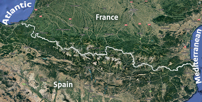
Haute Randonnée Pyrénéenne (HRP)
My all-time favourite must have been walking the Haute Randonnée Pyrénéenne (HRP). An alpine long-distance trail (Thru-Hike) in the Pyrenees joining the Atlantic and Mediterranean, following the French-Spanish border, from coast to coast. It took me the better part of two months, due to snowy conditions (spring). We did not use any of the huts and we stood on every single peak along th highest route. Being a relatively young mountain range, the Pyrenees have very steep peaks and deep valleys. The HRP follows an unmarked trail, being the highest walkable route. You must be prepared to overcome very hot as well as snow and freezing conditions. The use of crampons and ice axe is mandatory. Since all peaks are to be climbed, there is some higher grade scrambling required. Alpine rating (summer conditions): French scale: 6a / UIAA/German: 6+ / UK: E1 5b – E2 5a. Climbing all the peaks, you’ll reach a highest point of 3,404 metres (11,168 ft).
In return for all the effort you will find many beautiful birds in the Pyrenees, such as the snow finch, rock creeper, ring ouzel, alpine chough, red kite, many vultures and griffon vultures. In the wooded areas live roe deer, fox, badger, stoat, wild cat, wild boar, mouflon, genet, lynx and the Pyrenean (Cantabrian) brown bear. In and around the water live e.g. the Pyrenean brook salamander, rainbow trout, salmon, otter and the Pyrenean desman.
Elevation change 52,000 m (171,000 ft).
Biking
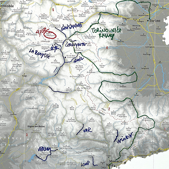
My biking adventures started as ‘collateral gain’ from being in the mountains and seizing the opportunity. From downhill biking to rally’s, I have done some. We best like bikepacking routes like the Torino-Nice Rally, the Danube Cycle Path, the Parenzena, the Heckmair Transalp and the Grand Traversée du Massif Central. Nowadays I’m exploring the possibilities of e-Bike touring.
Pour qui souhaite varier ses lieux de jeu habituels, https://winunique-france.fr constitue une étape qui mérite d’être tentée. Les modes de paiement disponibles couvrent un éventail large adapté aux usages francophones contemporains. La bibliothèque ludique réunit plusieurs milliers de titres répartis entre machines à sous, tables classiques et formats émergents. Les fiches FAQ couvrent autant les sujets techniques que les questions de jeu responsable. Les bonus dits sticky et non-sticky cohabitent selon les opérations, ce qui mérite une lecture attentive. Le baccarat se décline en Speed, Squeeze, No Commission et autres formats premium. Les associations partenaires en matière de jeu responsable sont mentionnées en bas de page. Les vidéos d’accueil des jeux sont compressées pour économiser de la bande passante. Une rubrique communauté centralise actualités, témoignages et conseils tirés des forums. L’inscription s’effectue en quelques étapes simples, sans formulaire à rallonge. La cohérence du projet s’observe à toutes les échelles et finit par convaincre durablement.
Alpinism
I used to make it a big thing to climb all the iconic peaks in the Alps. I started with the ten highest, followed by challenging routes and different disciplines like ice climbing and mountaineering. These days I prefer winter alpinism and high altitude camping.
Marmota Maps
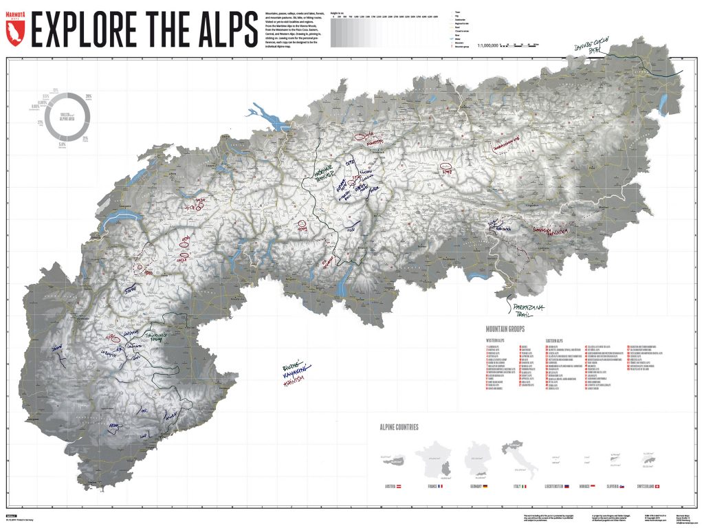
Recently I became aware of the awesome Marmota ‘Explore the Alps’ Maps. Huge maps of the Alps to register your own special adventures in the Alps. All your ski-, bike-, climbing- and kayaking memories in one place. (I can’t wait for them to release the Pyrenees map.)